Silk Wind and Current Map, 1944
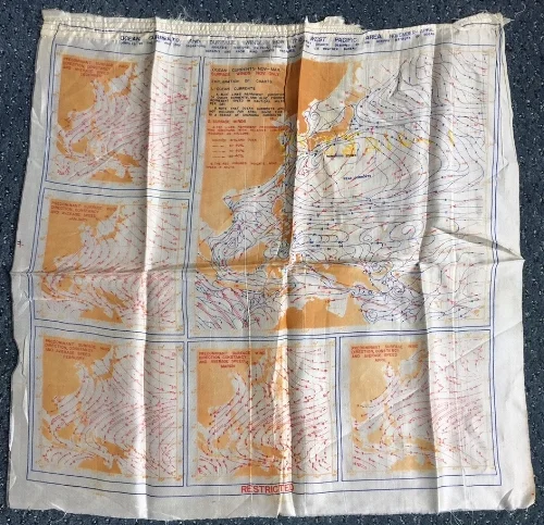
Ocean Currents and Surface Winds for the West Pacific Area, November-April. 18.5" x 18", silk, October 1944. This item from my personal collection is heavily creased, and shows dangling threads, presumably from when it was removed from a flight jacket. The charts were compiled by the 2nd and 3rd Operations Analysis sections, Headquarters of the Far East Air Force.
Lining flight jackets was one of the more surprising uses of climatological information during World War II. This map depicts the average ocean currents and prevailing surface winds of the Western Pacific from November through April. The map combines current charts designed by the Scripps Institution of Oceanography with wind data from the US Weather Bureau. The main chart on the upper right shows the ocean currents from November through March, and the surface winds for November. The inset maps along the left and bottom plot predominant surface winds for each month from December through April. Printed on durable silk with water-proof ink and then sewn inside the back of a leather flight jacket, the map was designed to help US pilots navigate their life raft and hopefully evade capture if they went down.
This map is one of many Escape and Evasion maps produced by the US and British militaries beginning during World War II. Pilots flying over land were issued topographical maps marked with vegetation, built up areas, and roads, to help them find places to hide and make their way to less friendly or neutral territory. The allies also tried to smuggle maps into German prisoner of war camps. One scheme involved specially marked Monopoly sets, with maps and currency tucked inside the board, and a compass hidden in a playing piece.
Like many objects of unknown provenance, it’s challenging to track the history of this particular item. I bought the map from a seller through eBay about 10 years ago, who had no more information than what was printed on the map. But according to research described by the unsigned author of escape-maps.com, maps like this one were produced in October 1944 by the Cartographic Section of the Royal Australian Air Force at the request of MIS-X. (MIS-X was a secret branch of the US War Department established to help servicemen evade and escape capture. It’s no longer clear what the acronym stood for, if it ever stood for anything.) The map was printed on fabric specially sent from the US to Australia, possibly rejected parachute silk. Over 21,000 copies of this chart were produced, along with 8,000 copies depicting winds and currents for May-September.
Learn More:
- "The History of World War II Escape Maps," Escape-Maps.com (retrieved May 22, 2017). See Section II, G, "RAAF Silk Escape Maps Produced for MIS-X".
- Megan Garber, "How Monopoly Games Helped Allied POWs Escape During World War II," The Atlantic, January 9, 2013.
- Central Intelligence Agency Museum, "OSS Escape and Evasion Map," (posted September 6, 2010).